Friday, April 30, 2010

Little River Trail Runs 2010 Donation: $5,000


(photo by Sidetrack)

Layna Mosley (right), co-director for the 2010 Little River Trail Run, presents a $5,000 check from the run's proceeds to Mike DiFabio and Michelle Pez, representatives of Little River Regional Park. Since 2006, the TrailHeads Running Club has organized annual trail runs to benefit the park in northeast Orange County, raising more than $22,000 toward the purchase of tools and for the maintenance of the park's mountain biking and hiking trail network.


Nice to have the opportunity to give back.

More at TrailHeads.org

Wednesday, April 28, 2010

Art Loeb Trail Adventure


What fun...

Arrived Davidson River Campground in Brevard Thursday evening, 4/22 and set up camp just before dark. Humid and warm.

Hit the trail Friday morning and went up the Art Loeb Trail to Catpen Gap...took a nap there, then came back through the campground on the North Slope trail, stopping for a spell at the swimming hole. Back at my site just as Goofus, Wolf and Mike Phillips were about done setting up their site.

Zephyr and Rob McClure arrived shortly after dark and set up their tents; Schnzl and Qwyk dropped in a short while after them.

Up early to get up to Graveyard Fields and start the ascent to Black Balsam Knob and beyond. The goal was Cold Mountain, but we were halted by serious weather at Shining Rock. Wolf rescued us by waiting in his van where the Art Loeb heads towards Black Balsam...gave Qwyk, Schnzl, Goofus and I a ride back to my car. Then we picked up all the others where the jeep trail ends near the Art Loeb connector.

We were all cold and soaked. Cleaned up at camp and hit Marco's in Brevard for a couple of pints and great pizza and Italian food. Later in the evening, there was some mention of bourbon...

A great weekend. I'm impressed by the team work - the communication that bonded us with a plan that avoided compounding errors. I'm glad we repeatedly regrouped so that we did not have to deal with uncertainty about who was where, why, or how.

I look forward to trying the route to Cold Mountain again...across The Narrows...with friends.

As Goofus put it:

WE PUT A WACKIN ON THE KRAKKEN
AND IF U THINK I'M JACKIN
THEN YOU'D BETTER BE PACKIN
CAUSE I'LL GIVE U A SMACKIN
AND YOUR EYES ARE GONNA BLACKEN
CAUSE WE GOT NOTHIN LACKIN
AND THAT IS A FAKKIN
JACKIN


(Zephyr has some great photos as well...on the TrailHeads ning site).


Monday, April 26, 2010

Pathways


(Inaugural Philosopher's Way Trail Runs Footage, May, 2008)

Over a decade ago a couple of friends and I met at Wilson Park to try something new: a run along Bolin Creek. I knew about the area, having lived in the Bolin Forest subdivision from 1983-1986. My wife and I enjoyed many outings along the creek with our golden retriever. Looking to "get away" from town a bit, we moved out Jones Ferry road to enjoy quieter and wilder spaces around our home.

But runs in town, in the Forest, became a weekly tradition with a group of us. I learned it was very quiet and wonderfully wild right in the heart of town! We would run the OWASA easement to the gate by the high school, go up the power line hill and then connect back to the creek trail and head back up the hill to Wilson Park. Then, of course, we'd hop down to the Open Eye Cafe for coffee and conversation before taking off to work. One day we decided to do something that's odd for most habitual runners - we altered our course, ducking a tree limb next to a rusted out Corvair and following skinny little pathways into an area of the Forest we had yet to explore. We continued to do this week after week - taking the little trails, which we learned to refer to as "single-track" - and the Forest opened up to us. The trail along the creek was always a reliable way-finding location, but the single-track led us to places in the heart of the Forest with varied terrain and countless opportunities to observe nature.

Our running habits changed. Each run became more about discovery than distance, and as time went by we tapped into the broader community of active citizens who watch, protect and envision a healthy future for the Bolin Creek corridor and what is now known as Carolina North Forest. The little group of "trail runners" - as we began calling ourselves - loosely organized into an informal club self-dubbed The TrailHeads, and, as we grew to understand the connected nature of and in the Forest, we expanded our courses to the Chapel Hill side of the Horace Williams tract and learned new spaces and trails there. On one run, probably seven or eight years ago an idea was hatched to host a race in the Forest if ever the opportunity presented itself. The Pumpkin Run was already an established venue, but our hope was to bring runners into the heart of the Forest, to course along the single-track instead of the wide gravel roads. This is a different experience for runners - it's less about individual and steady cadence than it is about moving together in a line of fellow runners to the rhythm of the terrain.

It was not until roughly three years ago that an opportunity did in fact present itself to bring other runners to the Forest. After discussions with Greg Kopsch, CNF manager, we were encouraged to formally submit a proposal to UNC for a set of trail races on the Chapel Hill side of the Forest. To honor Horace Williams, who referred to this tract of land as his "temple of trees," we named the races the Philosopher's Way Trail Runs. “Philosopher’s Way” evokes a couple of meanings – one of a pathway or trail and the other a methodology. The race then would signify a trail through the forest but also serve as a metaphor for a manner to incorporate thoughts on the trail into everyday life. The race's slogan is, simply: Enter, Learn, Return.

As race organizers, the TrailHeads had only one substantial hoop to jump through - we needed to incorporate as a 501 (c)(3) organization in order to, of all things, secure insurance for the event. Why would a disorganized bunch of trail runners want to do such a thing? Well, that led the group - no longer three, but consisting of an active core of members numbering nearly fifty - to consider a mission statement that would serve as the purpose for the organization. We found that this statement serves the club as well as the underlying rationale for the races in the Forest:

The purposes of this organization are to: promote the joy of trail running; support the efforts of members to maintain an active and healthy life style; listen, learn and internalize the lessons taught by our natural environment and wilder spaces; and organize and encourage efforts to enhance, extend, and maintain Nature's reach into the lives of each member of our greater community.

And that pretty much sums it up. I don't know that any of us thought ten years ago that the trail from Wilson Park to the Bolin Creek pathway would lead us off into a network of wooded trails that would rewire our network of activity and provide an outreach for our energy that is less about running miles than it is about participating in a community that treasures the forested island in the heart of Carrboro and Chapel Hill. I feel incredibly fortunate to have discovered this pathway, Bolin Creek, the Forest, and the many friends encountered along the way.

oh...the 3rd Annual Philosopher's Way 15K and 7K Trail Runs start at 8:00 a.m. on Saturday, May 8th. More info at www.trailheads.org


Sunday, April 18, 2010

Garden Trail, 2010

Paula's out of town at the beach with friends. I enjoyed the cold front that moved in yesterday around 3pm as I planted a few things in the garden - several varieties of peppers and tomatoes, some basil, parsley, oregano and cilantro. I was wondering if the plants might be a little insecure - transplanting from Southern States to our garden - so I figured I'd just sleep out with them, and listen to hear any suffering or requests for assurance.

It was a beautiful evening - starry and clear, gentle breezes that caught the wind chimes, Clarence trying to nudge me off the sleeping pad so he could have a softer surface.


We woke just before dawn to birdsong (and the neighbor's roosters). There are so many voices in the trees.


The wild roses on the fence line are blooming, probably about a month early this year.


I enjoyed this. Excellent sleeping conditions, cool, and early enough in the season to not have to worry about insects. The plants were very quiet.

Sunday, April 11, 2010

A Favorite Loop

I like loop courses. I enjoy starting at a place, heading in one direction and returning to the start from a different direction.

Yesterday, for the third time, I started down a favorite loop just off the Skyline Drive in the Shenandoah National Park. Weather was beautiful - temps perfect, clear skies.

The first time I attempted this run was in late May of 2008 and everything was blooming along the trail.

[click photos to enlarge]


The loop is about 15 miles up Skyline Drive from 64, about 20 miles from Charlottesville. I park at the Wildcat Ridge area, cross the AT, head down Wildcat Ridge, catch the Rip Rap Trail and then take the AT back to the parking lot. It's about a 9 mile loop, with some nice climbs and fairly technical stretches, strewn with rocks and roots.


(Photos taken in late May 2008)

Views are fantastic, particularly from the Cathedral Rock and Chimneys area. You can see the valley heading over to Harrisonburg and also take in views of the Massanutten area.


On my first attempt, I was trapped by a wicked thunderstorm...


...and had to spend about an hour huddled in the overhang of a cliff that hikers had surrounded with stonewalls.


I often marvel at how each trail run can be different due to seasonal shifts. Prior outings in this area were after the leaves were on the trees and the trail was shady and lush. This time, however, I was ahead of the canopy and the trail was doused in sunlight. The feeling was entirely different, and I stopped at one of several stream crossings to watch the light play on the water. (Perfect swimming hole for a summer outing)


I encountered several sets of backpackers. We chatted a bit. One group had seen a bear earlier that morning, so, the bears are awake (something for us to keep in mind when we head up to the Art Loeb in a couple of weeks.) My cell phone went off somewhere along the trail. Duncan had texted me with news that he had taken first place at the Inaugural Mountains to the Sea Trail run in Durham. He said the trail was nice and pretty fast. Sounds like he had fun. As I was putting my phone away I looked down and noticed a little friend on the trail, so, while she held her pose, I took her picture.


This is a lovely outing. Anytime you're in the area it's worth a trip over to do this very manageable loop. Just start down the path from the parking lot, cross the AT and follow the blue blazes. Keep your head up when you come to the 2nd stream crossing, the trail juts left around a switchback. If you go straight you'll wind up in that shelter mentioned above.

Take your camera and capture some of the views from the higher points (something I didn't do this time, but will do the next).

Here's the GARMIN route.


Here's a link to maps of the Skyline Drive.

Monday, April 5, 2010

Art Loeb Recon, Parts I & II


Duncan and I were dropped off in the middle of nowhere...we had hoped to take this road to pick up the Art Loeb near Farlow Gap and run 15 miles down to Davidson River Campground in Brevard. Plans changed. We couldn't drive over this bridge to get to the trailhead so we just took our stuff and a good map.

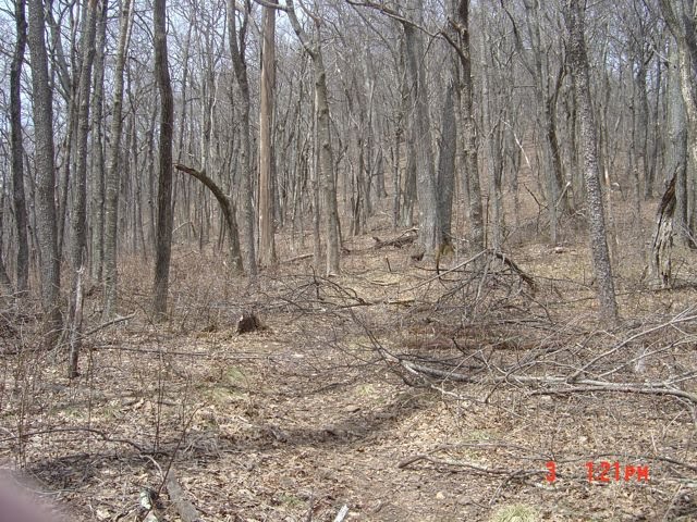
Reading a map is like learning a foreign language. Some "words" sound the same but have very different meanings. So, we took off and found an old forest service road, heading in what we hoped was the right direction. That "road" ended after about 2 miles, and we were sort of stupid to ever go down it - it was all grown up with stickers and we got shredded. We backtracked and looked at the map again, heading off in what I was hoping the right direction. We would know in about a mile, based on a stream crossing. We did cross a stream. Then, there would be another stream crossing in about another mile. There was. It seemed we were on the right trail, and we continued climbing.

Then the trail did something unexpected. Instead of one switchback that I had hoped would lead us to an intersection with the Art Loeb Trail, there was another switchback. I was, well, concerned, knowing that if we were not on course we'd have to run down the way we came, missing the trail entirely. Duncan suggested that perhaps the switchbacks were so close together that they were interpreted as a single switchback on the map. I checked the topography and it looked like we were in the right spot, with three knobs on our right and an apparent gap heading up toward the left. We trundled on.

Then the wind picked up and I could tell we were heading into a gap, just like on the map. A half mile later, our trail intersected the Art Loeb at Farlow Gap. Success, we found the trail...now what?


Decision time. Collectively, we were low on food and water. So, we decided to run up to the balds near the Parkway and call for a pick up, instead of running 15 miles down to Davidson River Campground. I was also worried about trail conditions. It looked like a bomb had shattered the treetops in the gap and the trail was in rough shape. Going all the way down would take a good long time.


The climb from Farlow Gap to the Blue Ridge Parkway is about a mile, but it's harder climbing than Uwharrie and about on par with the last section of Shut-In. We hit the Parkway at about 9.5 miles, and then continued to climb to the balds.


Again, the trail conditions were a bit sketchy, making tough going, tougher.


Finally near a ridge at around 6,000 ft elevation we entered a balsam forest with snow remnants and nice views.


We were able to connect with Paula via text and our plan was to run down to the falls near Graveyard fields and be extracted. So we did a little road running on the Parkway and went down to Lower Falls where I soaked my feet and washed off all the blood on my legs from the bramble scratches. The sun had warmed the rocks, so we finished most of our food and napped on boulders in the middle of the stream.


Awhile later we returned to the parking area and I observed something that I'd missed earlier: there was a blockade to the Parkway heading up to Asheville - the direction Paula would need to travel to pick us up. ooops. The Parkway was open from the other direction, but that would mean nearly a two hour drive for her and the rest of the family that was visiting in the mountains. So, we connected on cell and decided to meet at 276 and the Parkway near Mt. Pisgah. I was a little worried about our water status, but Paula said some rangers were driving up with some water for us.

We started running in the direction of Pisgah and after about a mile the rangers drove up, and very politely gave us 4 water bottles which we used to replenish our supply. They couldn't give us a ride however, because we were not in an emergency. Ok, fine. We continued running - Duncan moving easily ahead and stopping at the overlooks to wait for me to catch up.


Even though this was road running, I enjoyed it. How often do you get the opportunity to run the Blue Ridge Parkway entirely closed to traffic? But, what a mess! We were later told that the parkway from 276 to Graveyard Fields would be closed until June.


Looking across the ridges all the treetops were splintered from the winter storms. Eventually, (after about 4.5 miles) we were met by Paula, my brother-in-law, Dirk and his friend Derek who were walking in from 276 with more water and sandwiches. Duncan ran ahead and I enjoyed the remaining walk back to 276. Great memories... stunning views.


Lessons:

1. Forest Service roads can be impassable
2. Maps have to be interpreted
3. Food and Water should be measured on a model of double contingencies
4. Communication via cell is hit and miss
5. Positive outlook is essential

and it's great to know others are trying to think what you might do in the unexpected situation you find yourself in...

Great day "out there" - probably did more mileage than planned, and certainly spent more time on the feet than expected. That's good!

Here are the routes:

Start to Graveyard Fields (add 2 miles to total, note elevation gain from Farlow Gap)


There's much to consider here related to the upcoming Art Loeb attempt in April. I doubt we can tackle it in a day.